Photo Guide
Photograph Socotra
right.
The island rewards patience. Where to be before dawn, what's worth chasing at golden hour, what the wind does to your gear, and which frames are actually possible from a drone.
Pre-dawn
Best sunrise locations
Be on location 30 minutes before first light. The sky goes from cobalt to ember in under ten minutes — set up early.
- 01
Firmihin Forest
The world's largest dragon blood tree forest — 550 hectares of rolling limestone hills containing over 35,500 individual trees. Rolling plateau terrain with mushroom-canopied trees and a sparse, open understorey. Accessible by road via the Diksam Plateau or by multi-day mountain trek from the coast.
sunrisedrone - 02
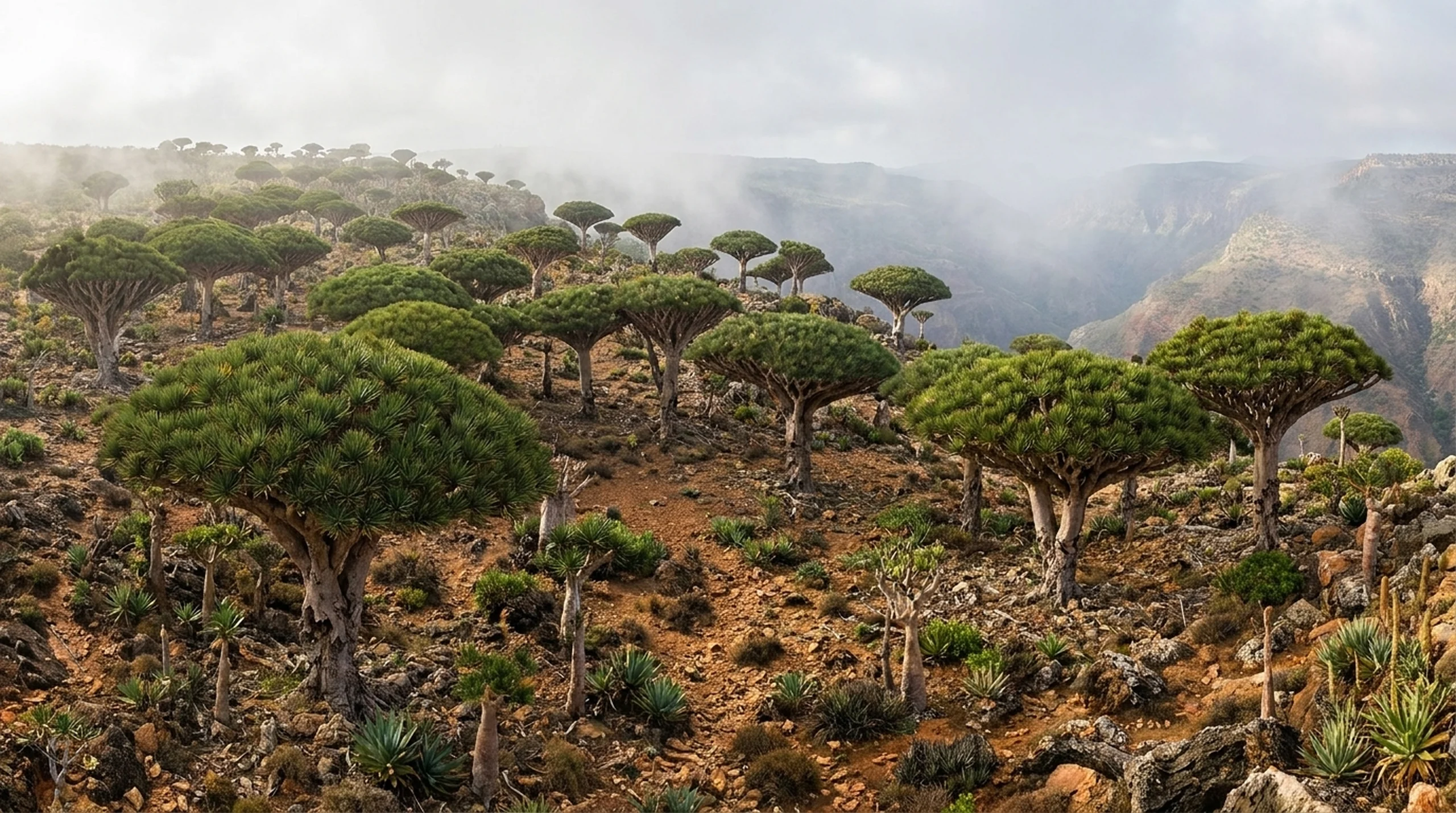
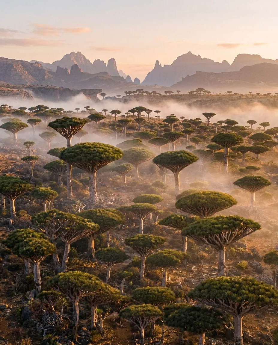
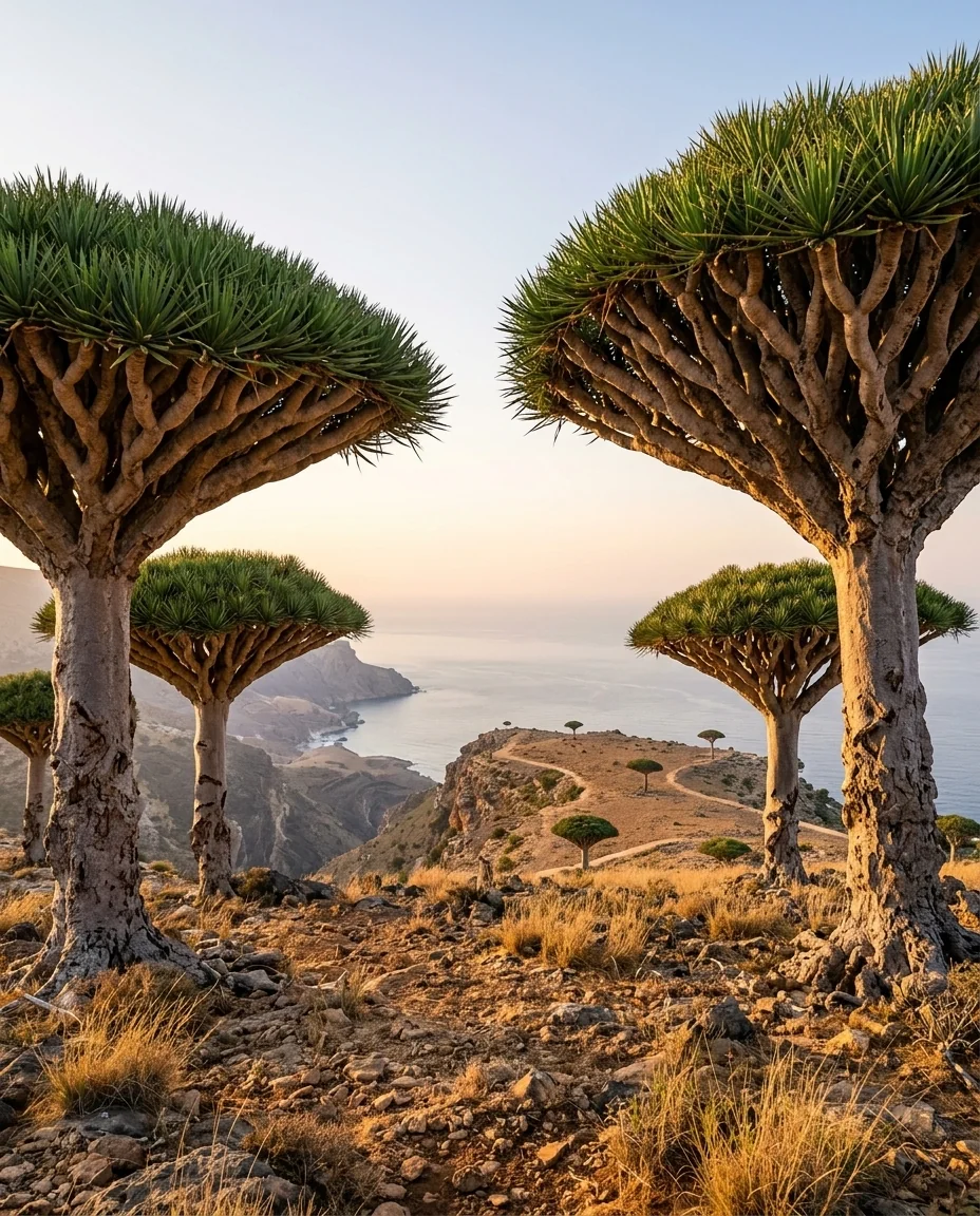
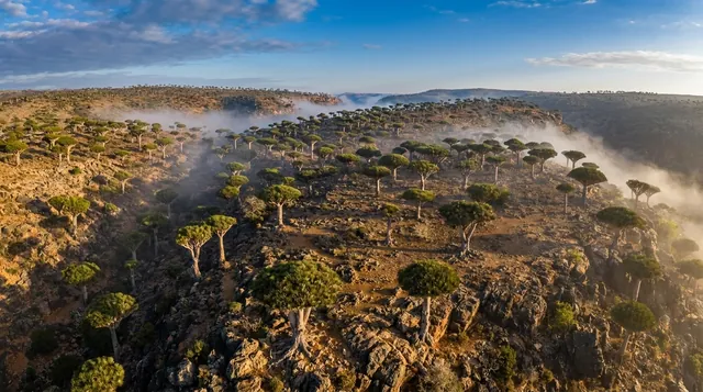
Diksam Plateau
A high limestone plateau carpeted in Dragon Blood Trees — Socotra's most iconic species. At sunrise, mist rolls through the umbrella canopies and the light turns the red resin glowing. Camp here overnight and you'll have the trees entirely to yourself.
sunrisesunsetdrone - 03
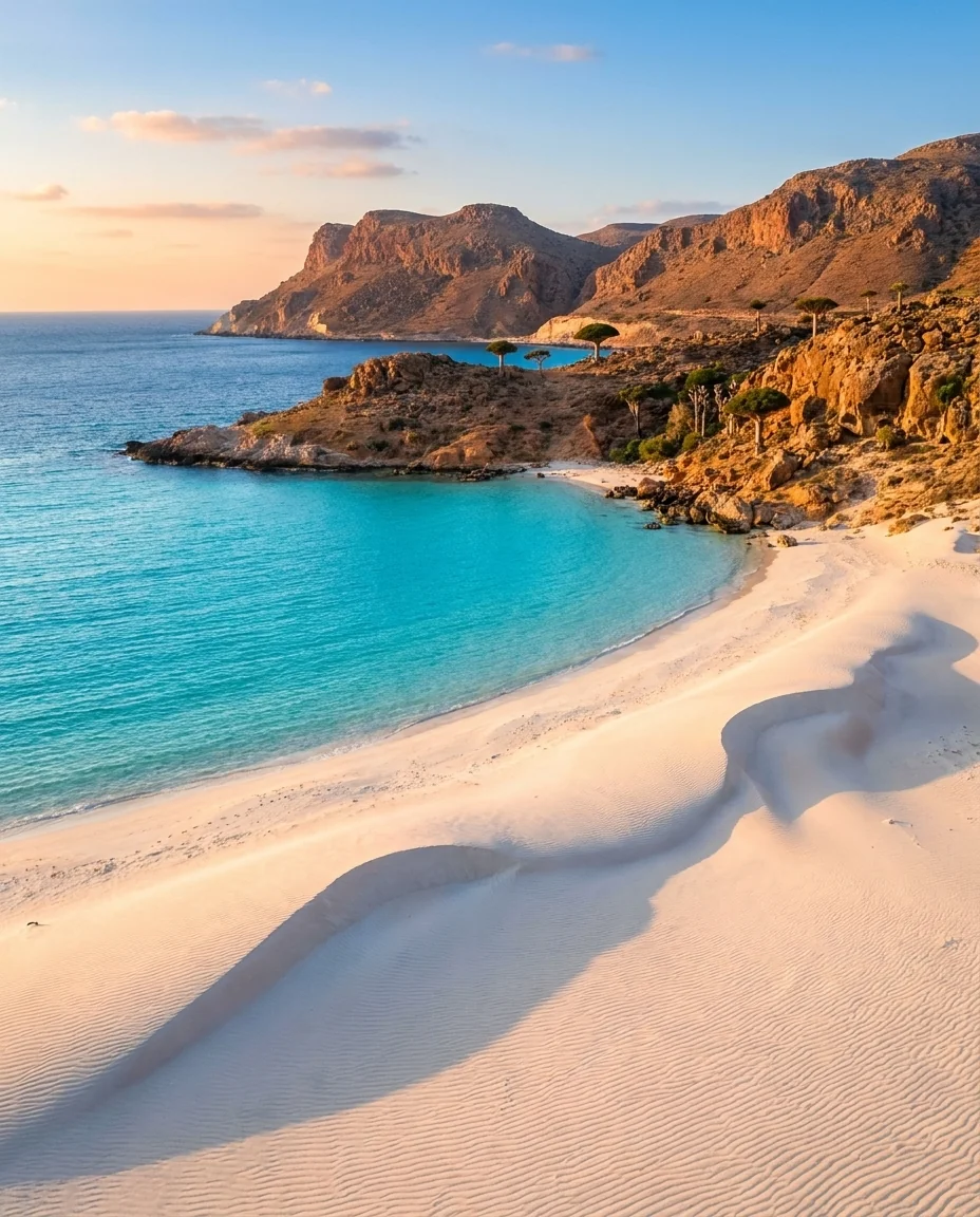
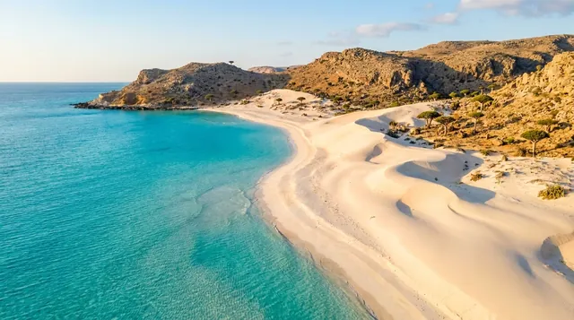
Mouri Beach
A north-coast beach near Socotra Airport with turquoise lagoons, calm morning water, and Dragon Blood Tree stands visible in the interior just behind the shoreline. One of the most accessible photography locations from Hadibo at approximately 13 km west of town.
sunrisemorningdrone - 04
Detwah Lagoon
A protected lagoon on the northwest coast, separated from the Arabian Sea by a narrow sandbar. The water is shallow, iridescent blue-green, and full of stingrays and small crabs visible from the shore. A 20-minute walk leads to a striking rock formation locals call the Caveman.
sunrisemorningdrone - 05
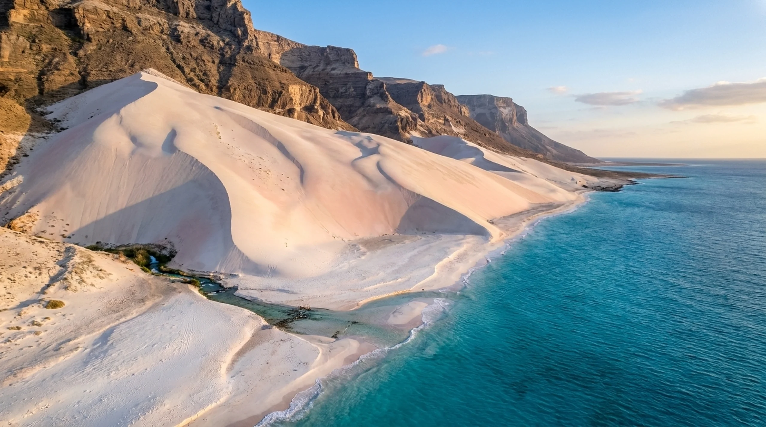
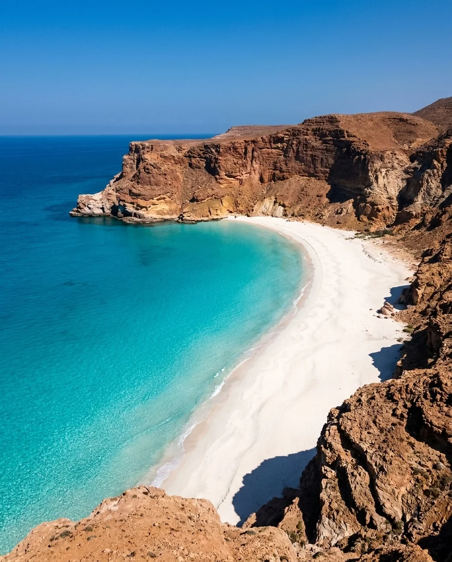
Arher Beach & Dunes
White sand dunes tumbling directly into the ocean on the east coast. The dunes reach 100m in places; at sunrise the light rakes across them in long shadows while the sea glitters below. Cliff caves are accessible at low tide. Strong wind reduces afternoon drone stability significantly.
sunrisegolden_hourdrone - 06
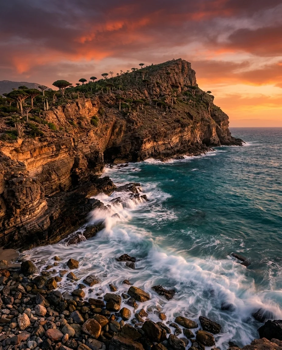
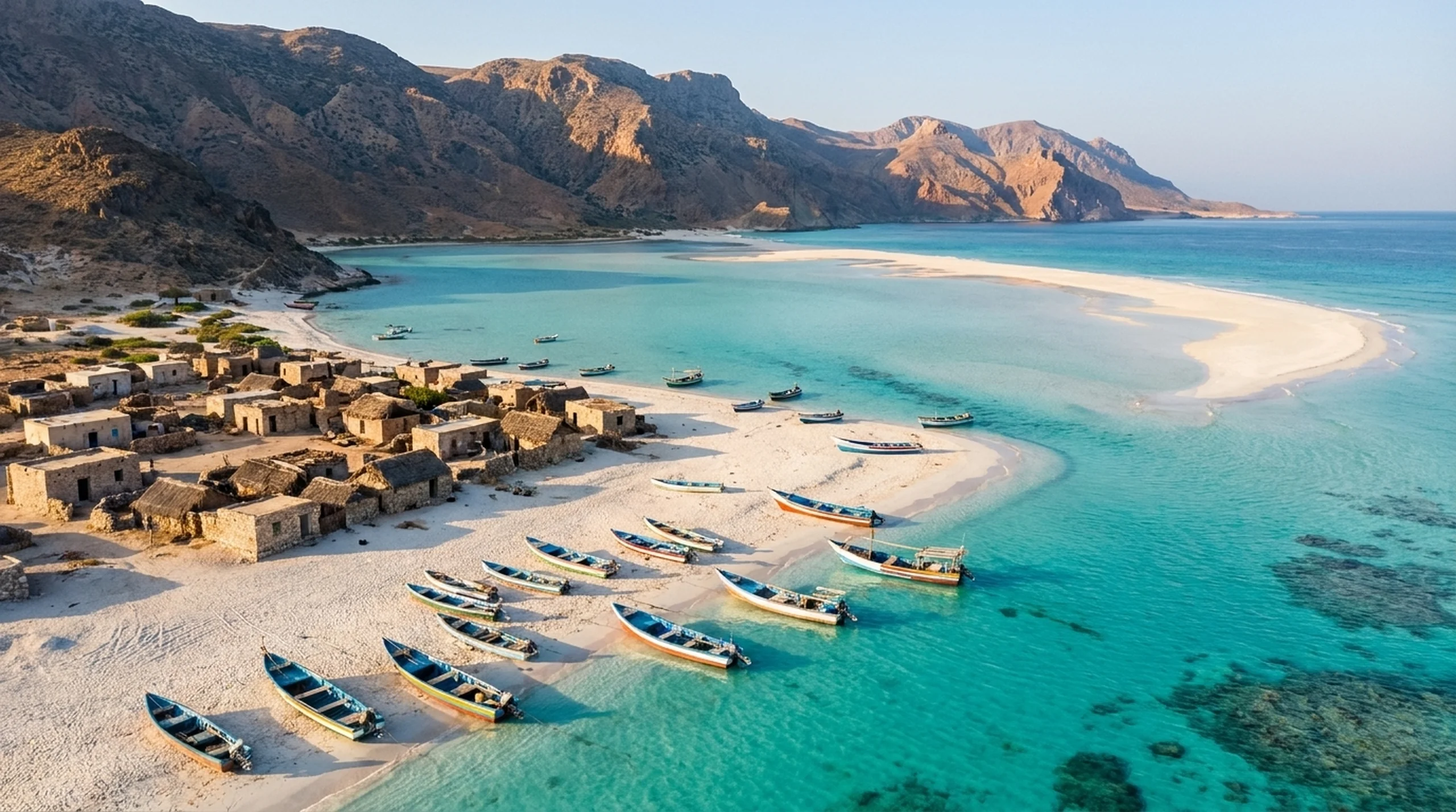
Ras Erissel
The easternmost point of Socotra where the Indian Ocean meets the Arabian Sea — amphibolitic bedrock at the tip of the island. The beach is littered with whale bones and puffer fish spines. The artisan fishing village of Erissel is nearby, where women craft traditional hebia belts.
sunrisedrone
Golden hour
Best sunset locations
Sunset works west-facing, but the real magic is in the after-light — that 20-minute window when the cliffs go magenta.
- 01
Diksam Plateau
A high limestone plateau carpeted in Dragon Blood Trees — Socotra's most iconic species. At sunrise, mist rolls through the umbrella canopies and the light turns the red resin glowing. Camp here overnight and you'll have the trees entirely to yourself.
sunrisesunsetdrone - 02
Moomi Plateau
A high red-rock plateau in eastern Socotra featuring some of the largest Bottle Trees on the island, set against pyramidal limestone spires and a Martian red landscape with alien succulent ground cover. Bedouin villages dot the plateau and Wadi Kalisan flows below the eastern rim. Diborak Waterfall is a short detour on the eastern edge when seasonal rains have filled it.
sunsetdrone - 03
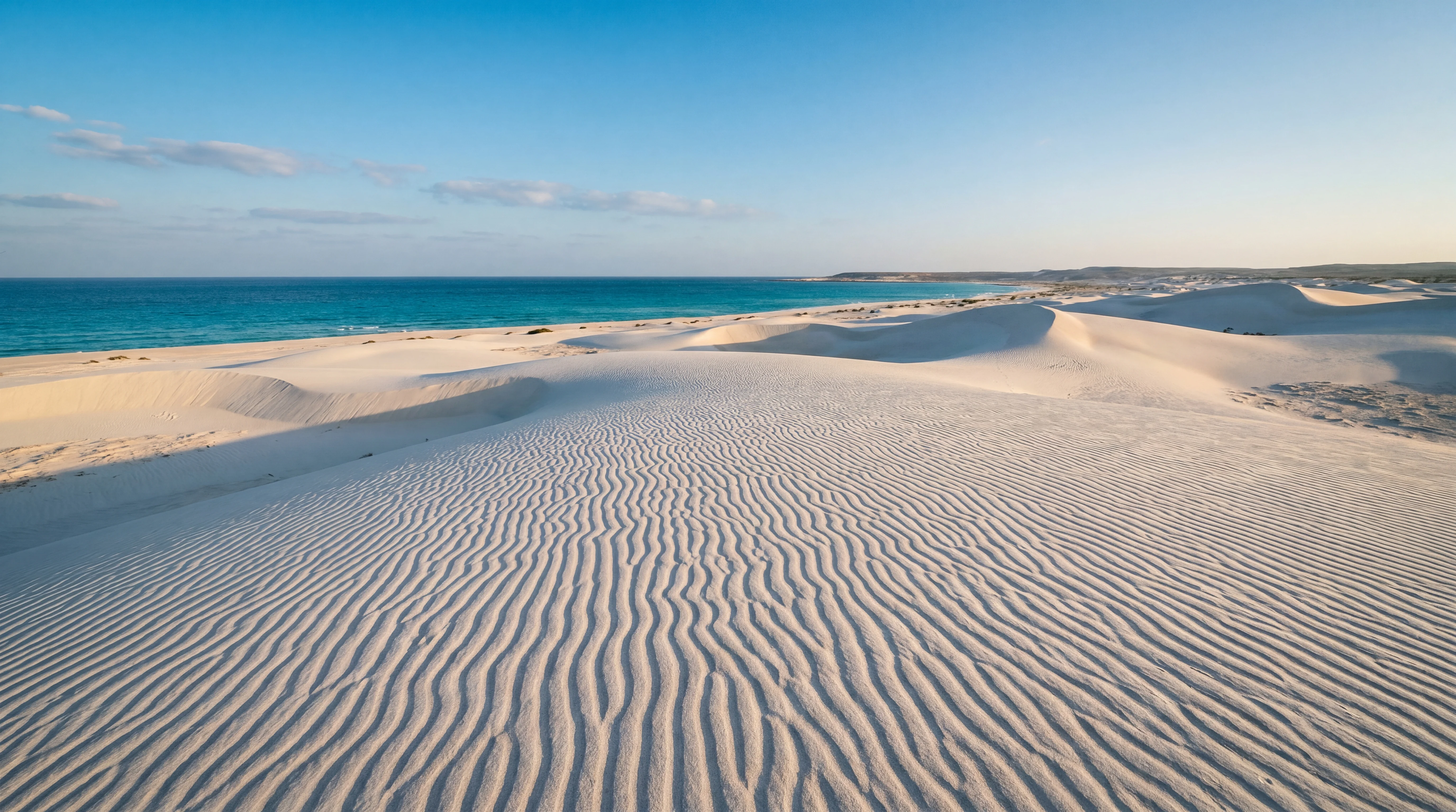
Aomak Beach
Socotra's longest beach — a crescent of ultra-fine white sand on the Indian Ocean's southern shore stretching for miles in near-total isolation. One of the few south-coast camping spots with freshwater shower and basic bathroom facilities. Dagub Cave is a five-minute walk away and Zahek Dunes are an easy drive east.
sunsetdrone - 04
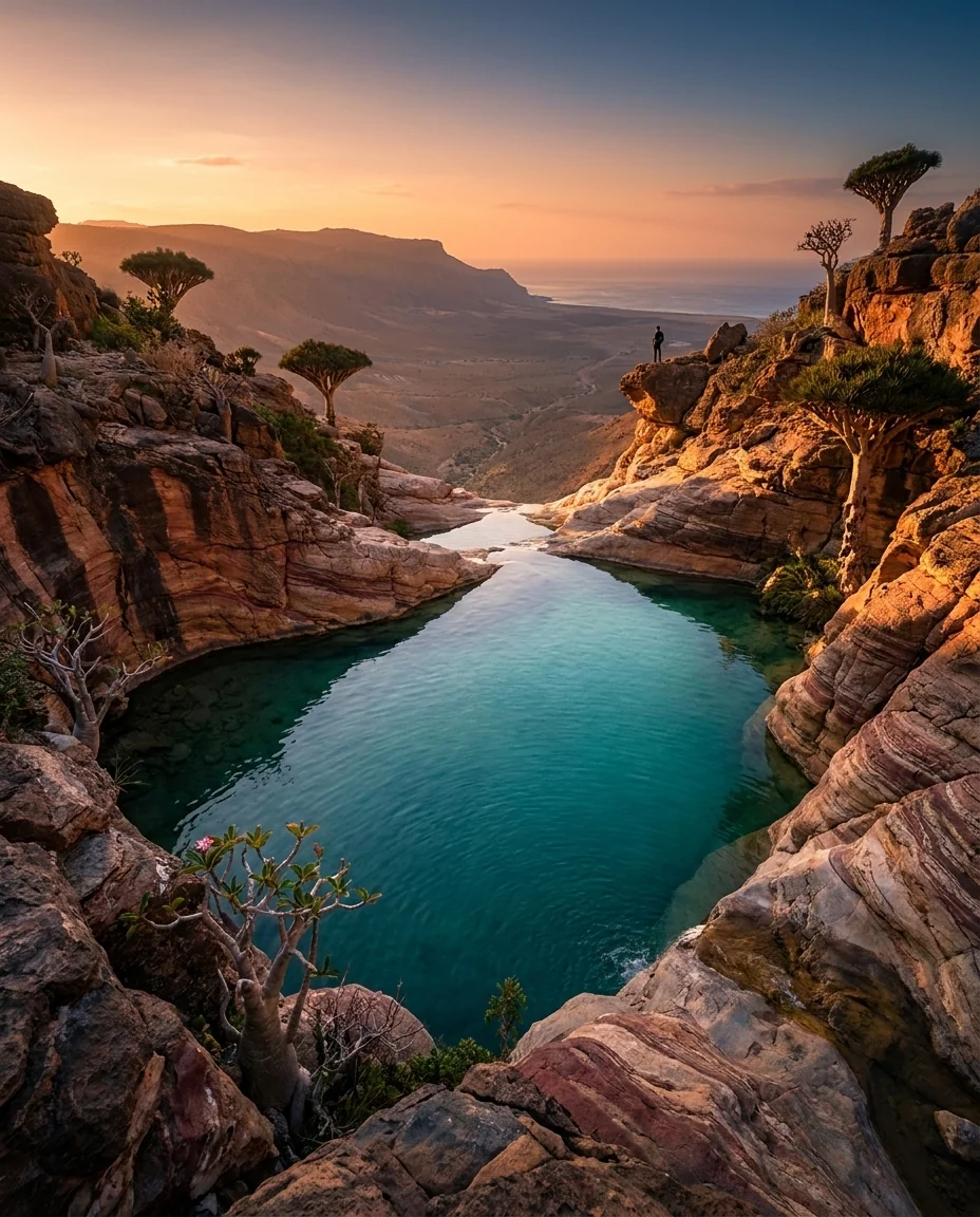
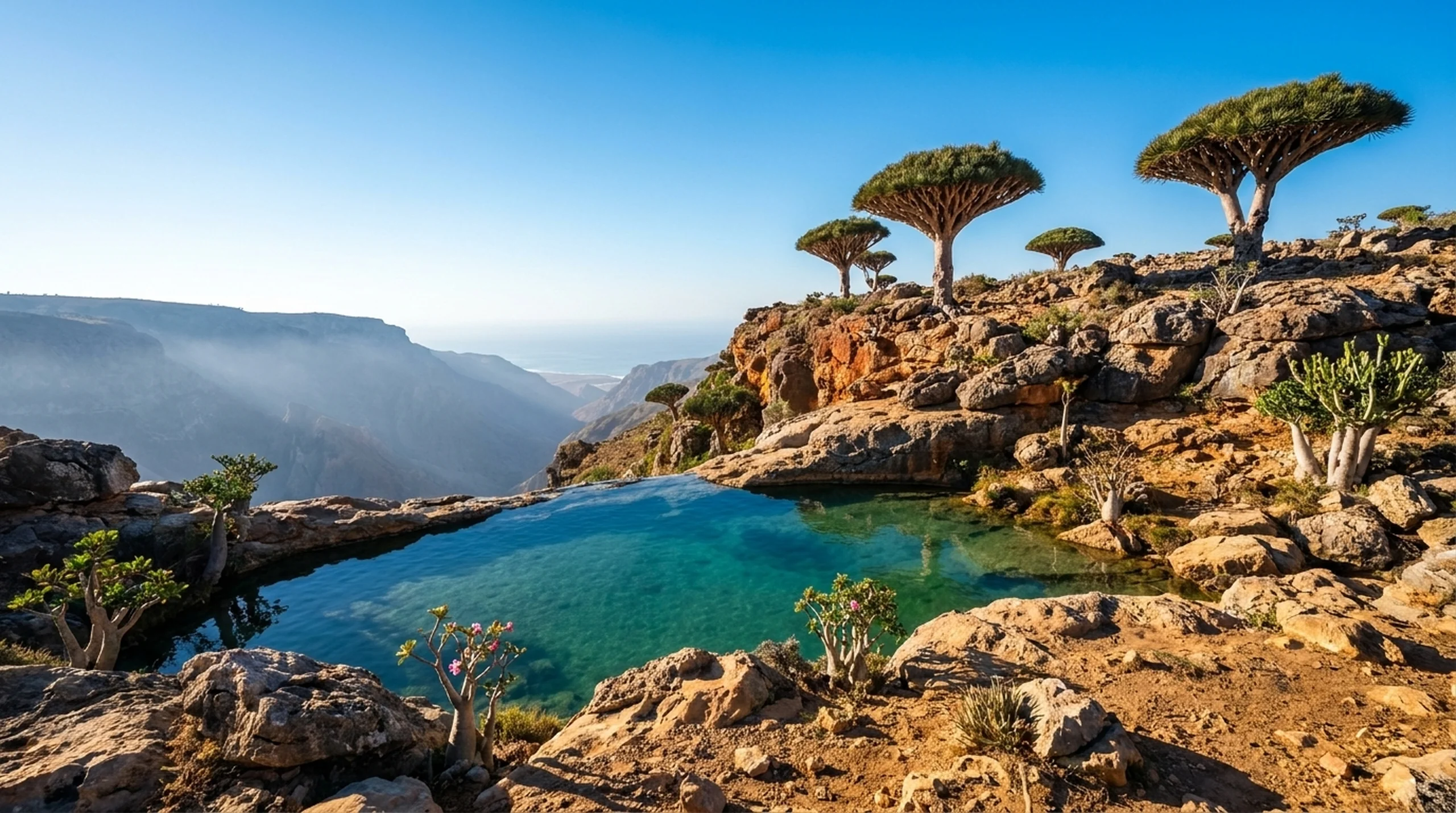
Wadi Shifa Infinity Pool
A natural infinity pool on the northern slopes below Homhil Plateau with unobstructed panoramic Arabian Sea views. The pool edge appears to dissolve directly into the ocean horizon far below — one of the most dramatic landscape compositions on the island. Accessed via a 2-hour trek north from the Homhil Protected Area.
sunsetdrone - 05
Rosh Cape
A jagged northeastern cape within the Rosh Marine Protected Area, featuring accessible sea caves, blowholes with dramatic spray, and nearshore marine life. Pairs with Ras Erissel as an eastern-tip photography itinerary offering different character — cave access versus open headland.
sunsetdrone - 06
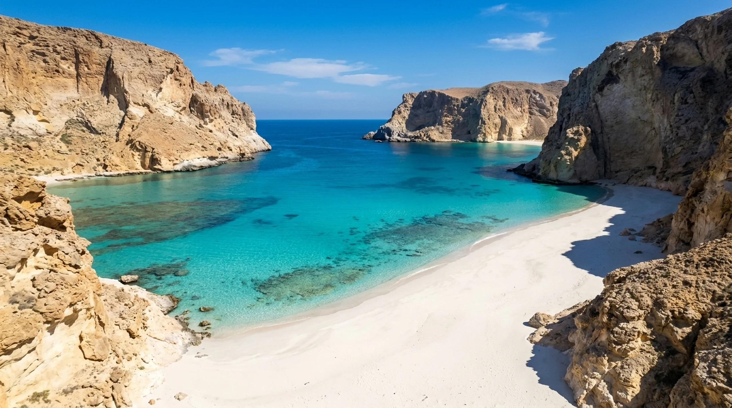
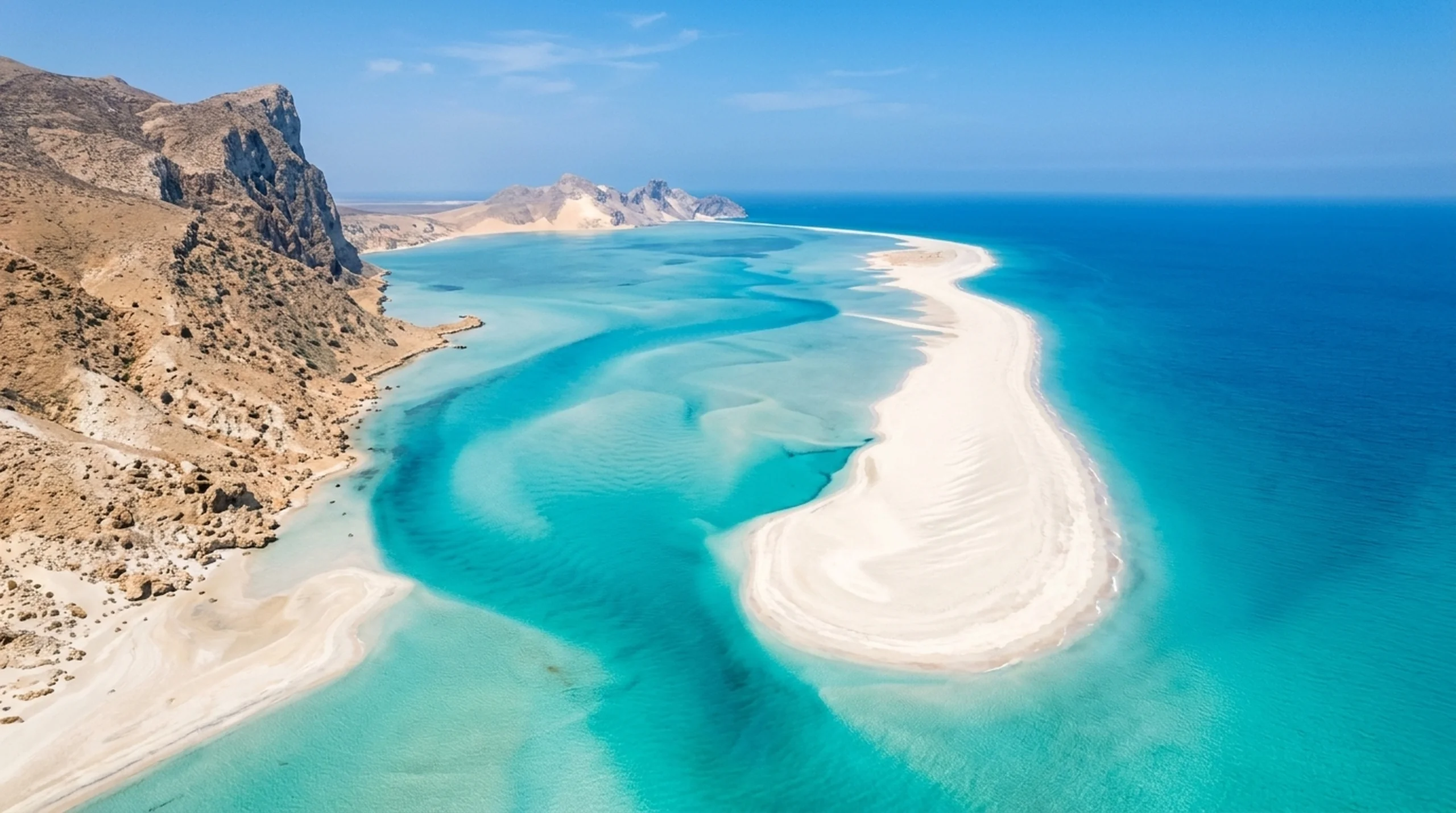
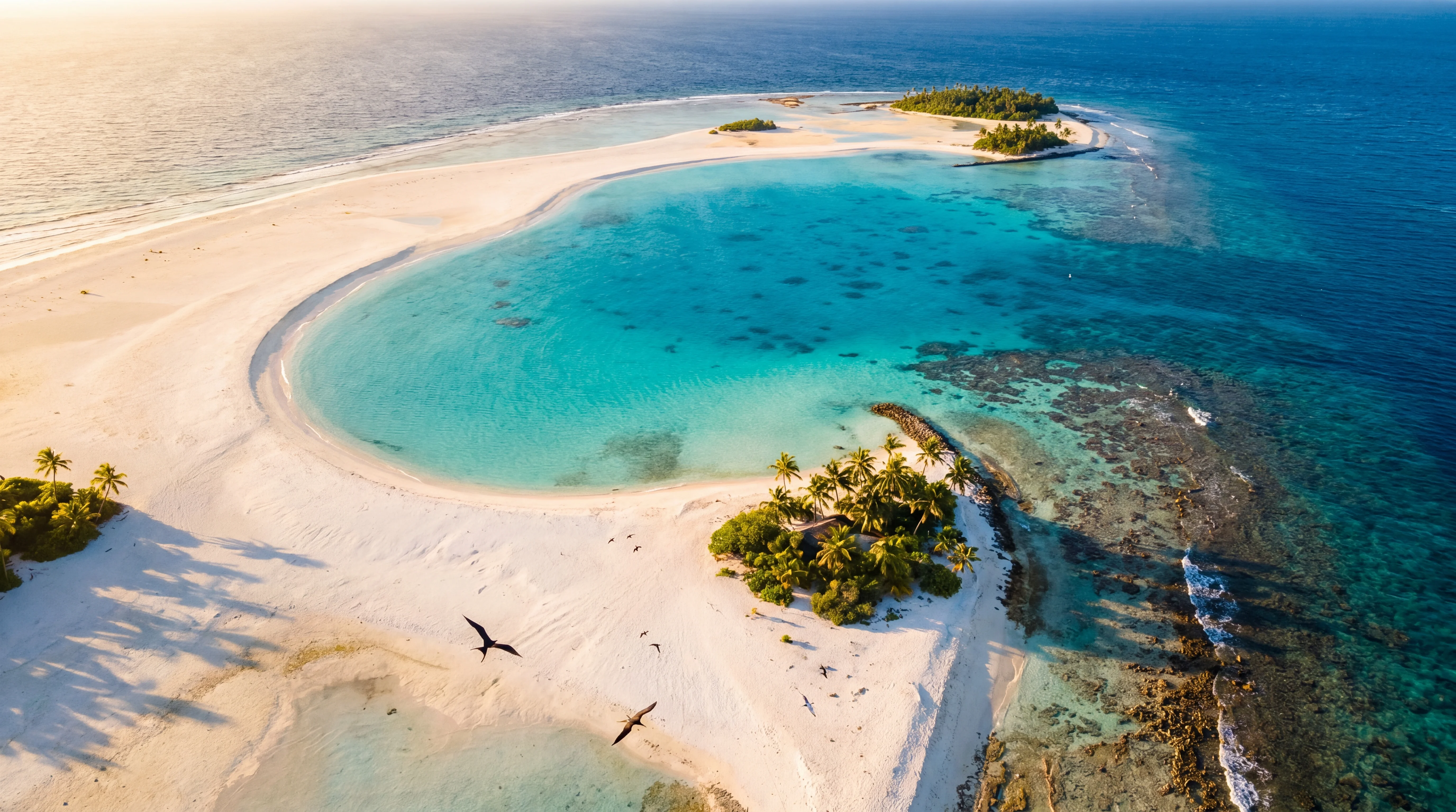
Shoab Beach
A double lagoon accessible only by a one-hour boat ride from Qalansiyah. The water shifts from deep blue to iridescent aquamarine between two natural rock barriers, creating a composition that looks like CGI. Dolphins are common on the crossing; whale sharks appear seasonally; bioluminescent plankton lights up the water at night.
morningsunsetdrone
Night sky
Astrophotography on Socotra
Bortle Class 2 — among the darkest accessible skies on the planet. Shoot the Milky Way through Dragon Blood Tree canopies at Dixam Plateau or Firmihin Forest. The galactic core is visible March through September; late April is the sweet spot before humidity builds.
Full astrophotography guide →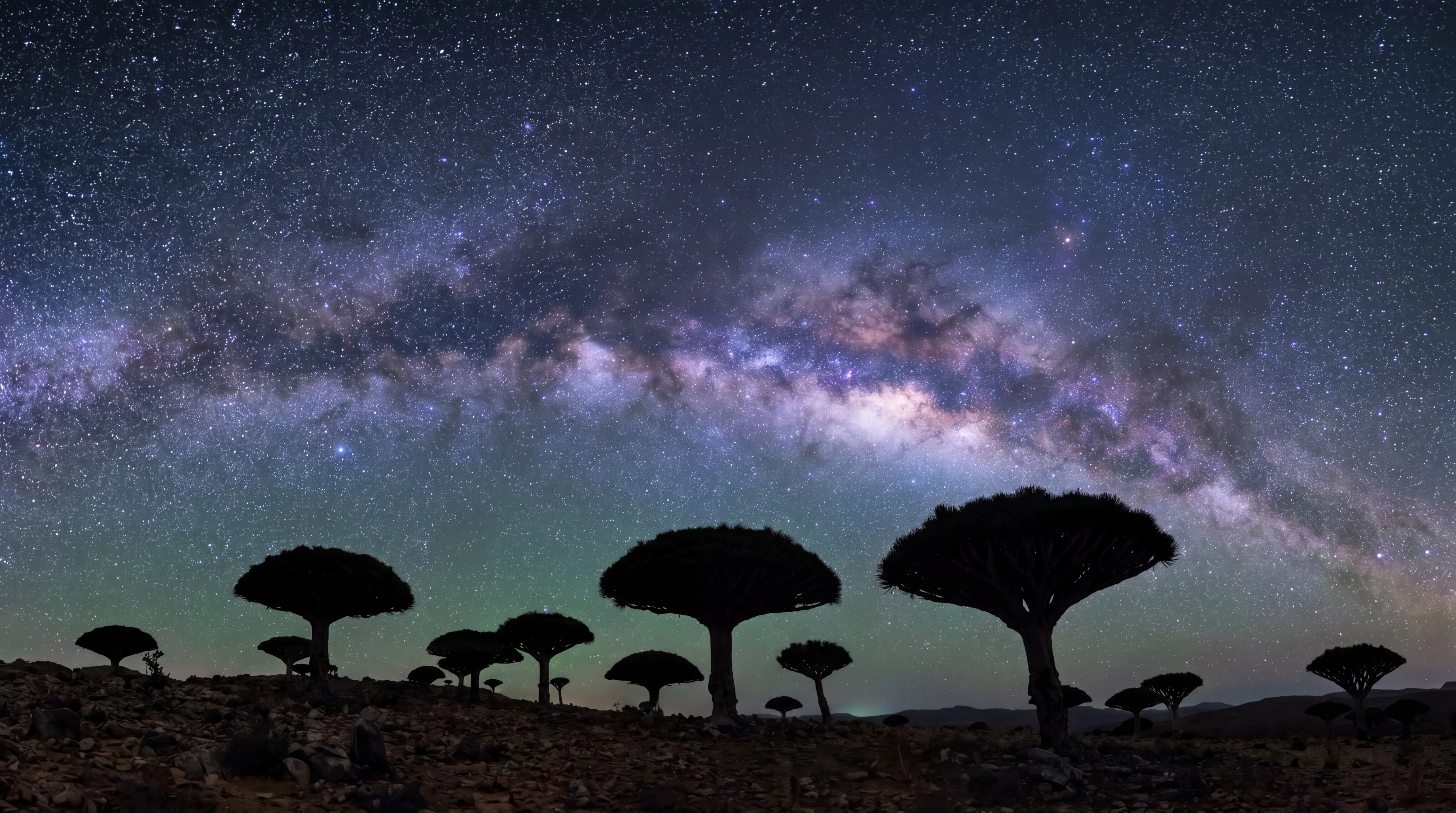
No night photography spots tagged yet.
Aerial
Drone photography
Permits are required. Wind kills most flights after 10am. These are the locations where it's worth the hassle.
- 01
Firmihin Forest
The world's largest dragon blood tree forest — 550 hectares of rolling limestone hills containing over 35,500 individual trees. Rolling plateau terrain with mushroom-canopied trees and a sparse, open understorey. Accessible by road via the Diksam Plateau or by multi-day mountain trek from the coast.
sunrisedrone - 02
Diksam Plateau
A high limestone plateau carpeted in Dragon Blood Trees — Socotra's most iconic species. At sunrise, mist rolls through the umbrella canopies and the light turns the red resin glowing. Camp here overnight and you'll have the trees entirely to yourself.
sunrisesunsetdrone - 03
Shu'ab Bay Beach
A remote white-sand crescent accessible only by a 1.5-hour boat ride from Qalansiyah, framed by towering cliff formations and sheltered by natural rock headlands. Spinner dolphin pods frequently escort the crossing; loggerhead turtles and whale sharks visit seasonally. Mangroves line the bay edges and the snorkelling reef is rich.
morningdrone - 04
Moomi Plateau
A high red-rock plateau in eastern Socotra featuring some of the largest Bottle Trees on the island, set against pyramidal limestone spires and a Martian red landscape with alien succulent ground cover. Bedouin villages dot the plateau and Wadi Kalisan flows below the eastern rim. Diborak Waterfall is a short detour on the eastern edge when seasonal rains have filled it.
sunsetdrone - 05
Mouri Beach
A north-coast beach near Socotra Airport with turquoise lagoons, calm morning water, and Dragon Blood Tree stands visible in the interior just behind the shoreline. One of the most accessible photography locations from Hadibo at approximately 13 km west of town.
sunrisemorningdrone - 06
Aomak Beach
Socotra's longest beach — a crescent of ultra-fine white sand on the Indian Ocean's southern shore stretching for miles in near-total isolation. One of the few south-coast camping spots with freshwater shower and basic bathroom facilities. Dagub Cave is a five-minute walk away and Zahek Dunes are an easy drive east.
sunsetdrone
Conditions
Wind & seasonal windows
The southwest monsoon shuts the island down June–September. The sweet spot is October–early May, with February clearest.
- 01
Shu'ab Bay Beach
A remote white-sand crescent accessible only by a 1.5-hour boat ride from Qalansiyah, framed by towering cliff formations and sheltered by natural rock headlands. Spinner dolphin pods frequently escort the crossing; loggerhead turtles and whale sharks visit seasonally. Mangroves line the bay edges and the snorkelling reef is rich.
morningdrone - 02
Moomi Plateau
A high red-rock plateau in eastern Socotra featuring some of the largest Bottle Trees on the island, set against pyramidal limestone spires and a Martian red landscape with alien succulent ground cover. Bedouin villages dot the plateau and Wadi Kalisan flows below the eastern rim. Diborak Waterfall is a short detour on the eastern edge when seasonal rains have filled it.
sunsetdrone - 03
Mouri Beach
A north-coast beach near Socotra Airport with turquoise lagoons, calm morning water, and Dragon Blood Tree stands visible in the interior just behind the shoreline. One of the most accessible photography locations from Hadibo at approximately 13 km west of town.
sunrisemorningdrone - 04
Aomak Beach
Socotra's longest beach — a crescent of ultra-fine white sand on the Indian Ocean's southern shore stretching for miles in near-total isolation. One of the few south-coast camping spots with freshwater shower and basic bathroom facilities. Dagub Cave is a five-minute walk away and Zahek Dunes are an easy drive east.
sunsetdrone - 05
Wadi Shifa Infinity Pool
A natural infinity pool on the northern slopes below Homhil Plateau with unobstructed panoramic Arabian Sea views. The pool edge appears to dissolve directly into the ocean horizon far below — one of the most dramatic landscape compositions on the island. Accessed via a 2-hour trek north from the Homhil Protected Area.
sunsetdrone - 06
Rosh Cape
A jagged northeastern cape within the Rosh Marine Protected Area, featuring accessible sea caves, blowholes with dramatic spray, and nearshore marine life. Pairs with Ras Erissel as an eastern-tip photography itinerary offering different character — cave access versus open headland.
sunsetdrone
Avoid midday
Where harsh light ruins the shot
Open, exposed locations where the sun between 10am and 3pm flattens contrast and burns out highlights. Shoot these at the edges of the day or skip them.
- 01
Shu'ab Bay Beach
A remote white-sand crescent accessible only by a 1.5-hour boat ride from Qalansiyah, framed by towering cliff formations and sheltered by natural rock headlands. Spinner dolphin pods frequently escort the crossing; loggerhead turtles and whale sharks visit seasonally. Mangroves line the bay edges and the snorkelling reef is rich.
morningdrone - 02
Mouri Beach
A north-coast beach near Socotra Airport with turquoise lagoons, calm morning water, and Dragon Blood Tree stands visible in the interior just behind the shoreline. One of the most accessible photography locations from Hadibo at approximately 13 km west of town.
sunrisemorningdrone - 03
Aomak Beach
Socotra's longest beach — a crescent of ultra-fine white sand on the Indian Ocean's southern shore stretching for miles in near-total isolation. One of the few south-coast camping spots with freshwater shower and basic bathroom facilities. Dagub Cave is a five-minute walk away and Zahek Dunes are an easy drive east.
sunsetdrone - 04
Detwah Lagoon
A protected lagoon on the northwest coast, separated from the Arabian Sea by a narrow sandbar. The water is shallow, iridescent blue-green, and full of stingrays and small crabs visible from the shore. A 20-minute walk leads to a striking rock formation locals call the Caveman.
sunrisemorningdrone - 05
Rosh Cape
A jagged northeastern cape within the Rosh Marine Protected Area, featuring accessible sea caves, blowholes with dramatic spray, and nearshore marine life. Pairs with Ras Erissel as an eastern-tip photography itinerary offering different character — cave access versus open headland.
sunsetdrone - 06
Shoab Beach
A double lagoon accessible only by a one-hour boat ride from Qalansiyah. The water shifts from deep blue to iridescent aquamarine between two natural rock barriers, creating a composition that looks like CGI. Dolphins are common on the crossing; whale sharks appear seasonally; bioluminescent plankton lights up the water at night.
morningsunsetdrone
Aerial · Golden hour
Best drone shots at golden hour
Drone-friendly locations where wind is manageable and the sun preference is clear. These are the highest-yield aerial frames on the island.
- 01
Firmihin Forest
The world's largest dragon blood tree forest — 550 hectares of rolling limestone hills containing over 35,500 individual trees. Rolling plateau terrain with mushroom-canopied trees and a sparse, open understorey. Accessible by road via the Diksam Plateau or by multi-day mountain trek from the coast.
sunrisedrone - 02
Diksam Plateau
A high limestone plateau carpeted in Dragon Blood Trees — Socotra's most iconic species. At sunrise, mist rolls through the umbrella canopies and the light turns the red resin glowing. Camp here overnight and you'll have the trees entirely to yourself.
sunrisesunsetdrone - 03
Moomi Plateau
A high red-rock plateau in eastern Socotra featuring some of the largest Bottle Trees on the island, set against pyramidal limestone spires and a Martian red landscape with alien succulent ground cover. Bedouin villages dot the plateau and Wadi Kalisan flows below the eastern rim. Diborak Waterfall is a short detour on the eastern edge when seasonal rains have filled it.
sunsetdrone - 04
Mouri Beach
A north-coast beach near Socotra Airport with turquoise lagoons, calm morning water, and Dragon Blood Tree stands visible in the interior just behind the shoreline. One of the most accessible photography locations from Hadibo at approximately 13 km west of town.
sunrisemorningdrone - 05
Aomak Beach
Socotra's longest beach — a crescent of ultra-fine white sand on the Indian Ocean's southern shore stretching for miles in near-total isolation. One of the few south-coast camping spots with freshwater shower and basic bathroom facilities. Dagub Cave is a five-minute walk away and Zahek Dunes are an easy drive east.
sunsetdrone - 06
Wadi Shifa Infinity Pool
A natural infinity pool on the northern slopes below Homhil Plateau with unobstructed panoramic Arabian Sea views. The pool edge appears to dissolve directly into the ocean horizon far below — one of the most dramatic landscape compositions on the island. Accessed via a 2-hour trek north from the Homhil Protected Area.
sunsetdrone
Wide angle
Best wide-angle landscapes
Open scenes that reward 16–35mm: dunes, lagoons, plateaus, and coastline. Sky-to-ground sweep is what these places deliver.
- 01
Shu'ab Bay Beach
A remote white-sand crescent accessible only by a 1.5-hour boat ride from Qalansiyah, framed by towering cliff formations and sheltered by natural rock headlands. Spinner dolphin pods frequently escort the crossing; loggerhead turtles and whale sharks visit seasonally. Mangroves line the bay edges and the snorkelling reef is rich.
morningdrone - 02
Mouri Beach
A north-coast beach near Socotra Airport with turquoise lagoons, calm morning water, and Dragon Blood Tree stands visible in the interior just behind the shoreline. One of the most accessible photography locations from Hadibo at approximately 13 km west of town.
sunrisemorningdrone - 03
Aomak Beach
Socotra's longest beach — a crescent of ultra-fine white sand on the Indian Ocean's southern shore stretching for miles in near-total isolation. One of the few south-coast camping spots with freshwater shower and basic bathroom facilities. Dagub Cave is a five-minute walk away and Zahek Dunes are an easy drive east.
sunsetdrone - 04
Detwah Lagoon
A protected lagoon on the northwest coast, separated from the Arabian Sea by a narrow sandbar. The water is shallow, iridescent blue-green, and full of stingrays and small crabs visible from the shore. A 20-minute walk leads to a striking rock formation locals call the Caveman.
sunrisemorningdrone - 05
Shoab Beach
A double lagoon accessible only by a one-hour boat ride from Qalansiyah. The water shifts from deep blue to iridescent aquamarine between two natural rock barriers, creating a composition that looks like CGI. Dolphins are common on the crossing; whale sharks appear seasonally; bioluminescent plankton lights up the water at night.
morningsunsetdrone - 06
Arher Beach & Dunes
White sand dunes tumbling directly into the ocean on the east coast. The dunes reach 100m in places; at sunrise the light rakes across them in long shadows while the sea glitters below. Cliff caves are accessible at low tide. Strong wind reduces afternoon drone stability significantly.
sunrisegolden_hourdrone
Telephoto
Best compressed scenes
Mountains, cliffs, and dragon-blood groves where a 70–200mm flattens distance and isolates the subject. These are the frames a wide angle would shrink.
- 01
Firmihin Forest
The world's largest dragon blood tree forest — 550 hectares of rolling limestone hills containing over 35,500 individual trees. Rolling plateau terrain with mushroom-canopied trees and a sparse, open understorey. Accessible by road via the Diksam Plateau or by multi-day mountain trek from the coast.
sunrisedrone - 02
Diksam Plateau
A high limestone plateau carpeted in Dragon Blood Trees — Socotra's most iconic species. At sunrise, mist rolls through the umbrella canopies and the light turns the red resin glowing. Camp here overnight and you'll have the trees entirely to yourself.
sunrisesunsetdrone - 03
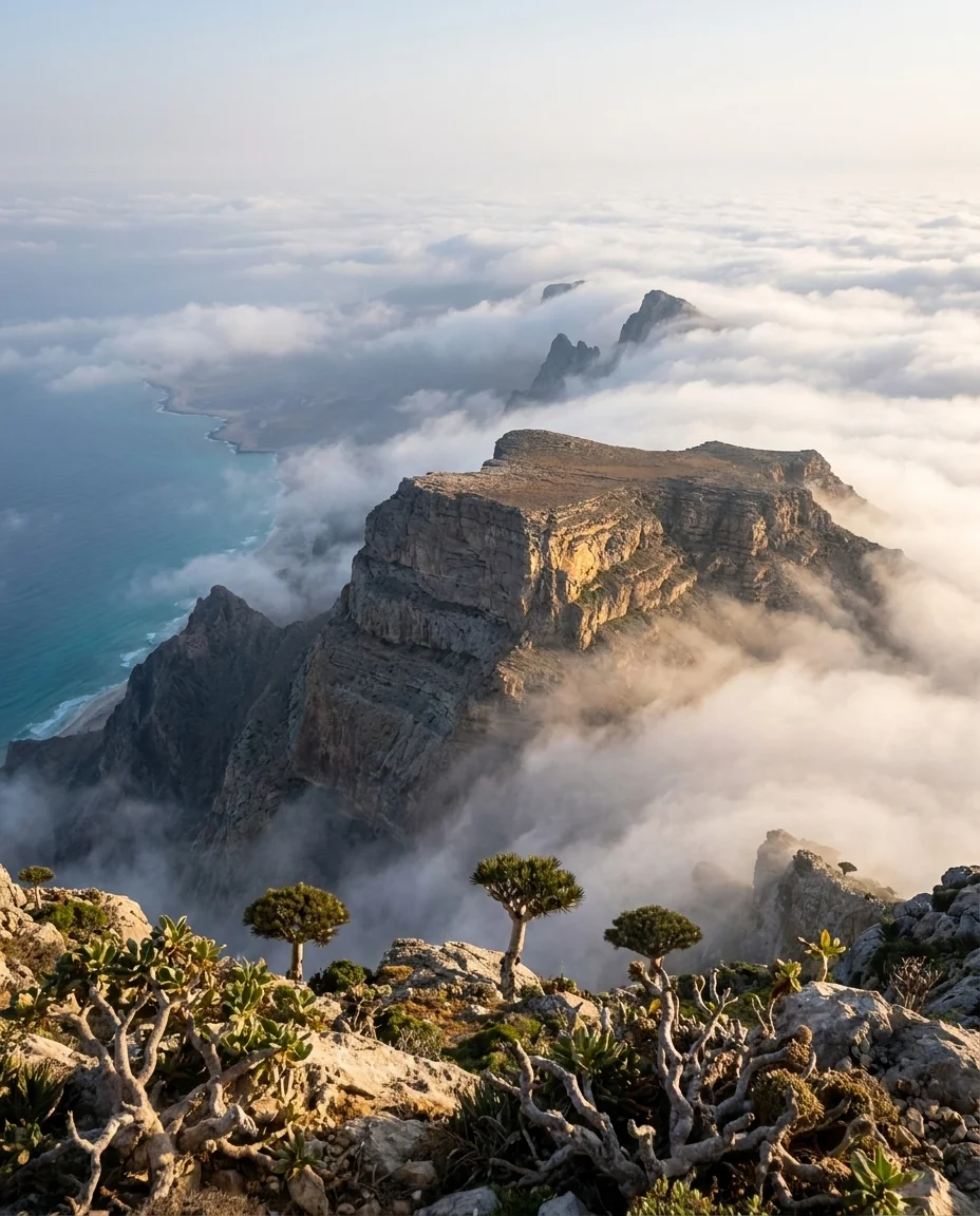
Skand Peak
Socotra's highest summit at 1,519 m — a dramatic jagged peak above the Haggier range reached by a six-hour day hike from Tarhar village. Egyptian vultures ride thermals from the summit. The Fera viewpoint en route, with Dragon Blood Trees growing on clifftops, is described by experienced trekkers as Socotra's most dramatic hiking composition.
morningdrone - 04
Homhil Protected Area
A protected plateau at 900m with the island's most famous natural infinity pool — a shallow freshwater pool that appears to spill directly into the Arabian Sea far below. The approach is a 4-6km hike each way through Dragon Blood Tree forest. Endemic frankincense trees and bottle trees grow along the trail.
morning - 05
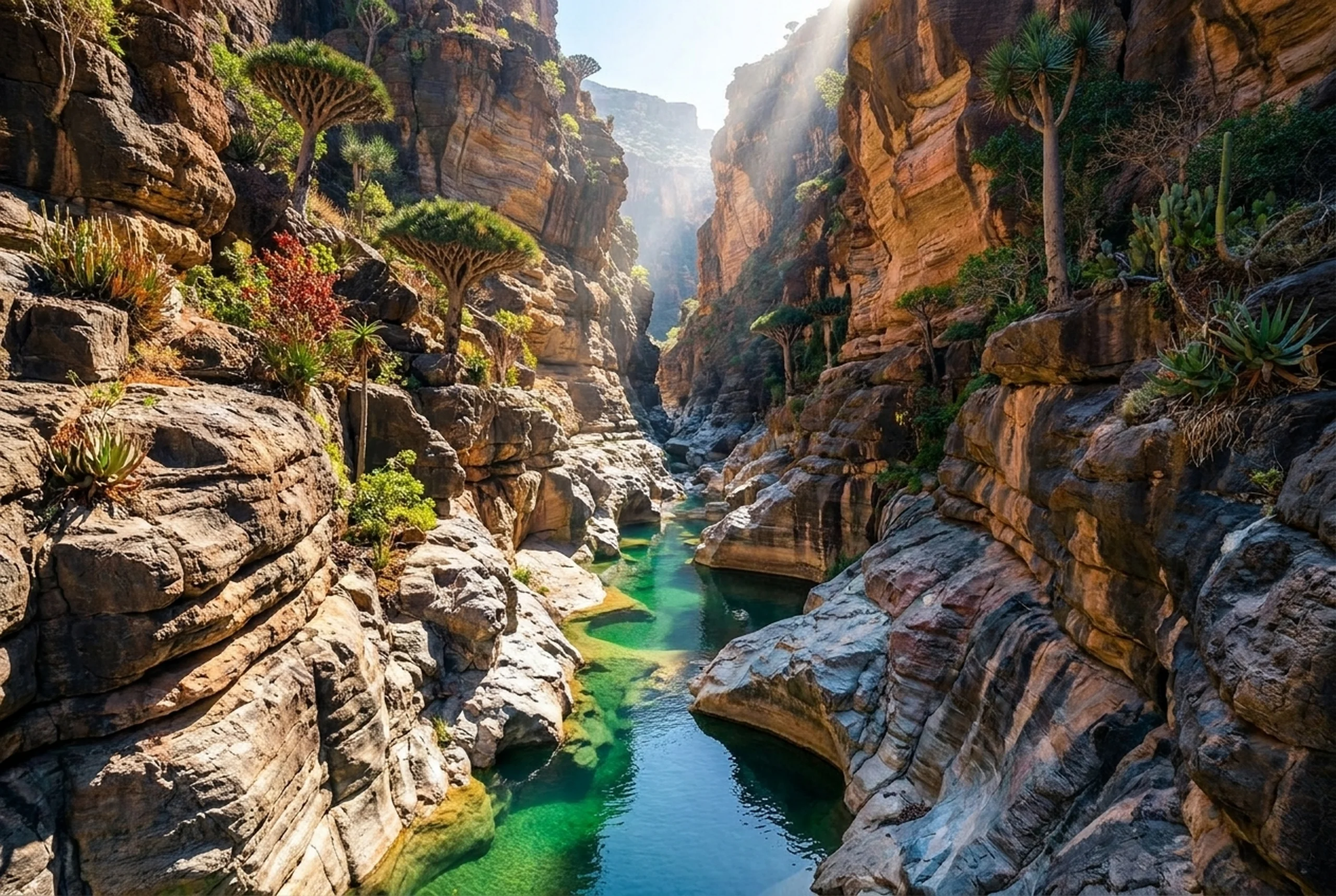
Wadi Klisen Canyon
A white limestone canyon carved by seasonal floods, with cold freshwater pools at its base. The walls are smooth and pale, the pools are deep and clear enough to see the bottom, and tamarind trees grow improbably from cracks in the rock. A 30-minute hike from the drop-off point.
morningmidday - 06
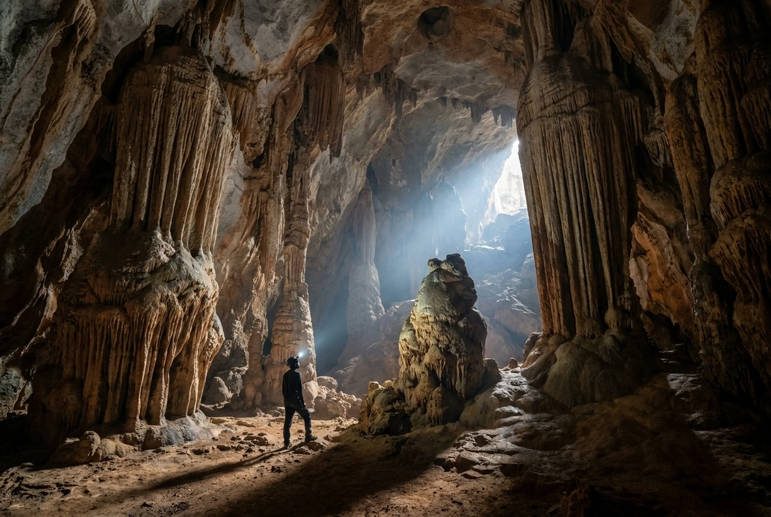
Hoq Cave
A 3km cave system on the northeast coast, reached by a 300m hike up a rocky cliff face. The cave contains 1st-century sailor inscriptions in multiple scripts — Palmyrene, South Arabian, Indian — left by mariners sheltering from storms. Stalactites and stalagmites throughout. Bottle trees bloom on the approach path in March.
morning
Where to shoot
Pick a window. Get a shortlist.
Tap an intent — we re-rank the island for you using time-of-day, photo value, drone access and wind sensitivity.
What are you looking for?
- 01
Firmihin Forest
Ideal at sunrise · strong photo value.
sunrisedronelow wind69 - 02
Diksam Plateau
Ideal at sunrise · strong photo value.
sunrisesunsetdronelow wind69 - 03
Detwah Lagoon
Ideal at sunrise · strong photo value.
sunrisemorningdronelow wind68 - 04
Mouri Beach
Ideal at sunrise · strong photo value.
sunrisemorningdrone63 - 05
Qalansiyah
Ideal at sunrise.
sunrisedrone58 - 06
Arher Beach & Dunes
Ideal at sunrise · strong photo value.
sunrisegolden_hourdrone41
Next
See the frames.
Browse the gallery — every image tagged by location, time of day, and whether it's a drone shot.
Open the gallery →